How to Read a River Map Across Different Dates
A river map records one view of a waterway. Learn to compare dated records and tell what they can—and cannot—reveal about its past course.
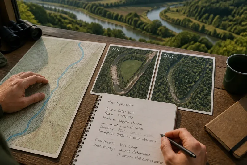
Open a river map beside a dated aerial image and the channel may seem to occupy two different places. Before calling either record wrong, check what each one depicts: a generalized map feature or the visible waterway on a particular day.
To read a river map as a historical record, focus on its source, date, scale, and purpose. Those details help distinguish changes in the record from changes in the river, without asking one blue line to tell the whole story.
What does a river map record?
A mapped line is a selected representation. Cartographers may simplify small channels to keep a map readable, and a regional map may omit features that are clear in a close aerial image. The line might represent a named watercourse, a mapped stream network, or another defined feature—not every route water can take.
Dates matter as much as detail. A map’s publication date may differ from the date its underlying waterway information was collected; an aerial layer has its own capture date. Look for source notes or layer information, and mark the date as unknown if the record does not provide it.
Which records help answer which questions?
Use a topographic map for landscape context
Contour lines, roads, valley shapes, and place names help locate a river within its surroundings. This is useful for orientation and broad watershed context, but a simplified stream line is not designed to establish the exact position of a channel on a particular date.
Use dated imagery to inspect visible features
Aerial imagery can reveal the shape of water and exposed land from above, including islands, channel traces, or branching routes. Compare the image dates and note conditions that may affect visibility: tree cover can hide a channel, while exposed sediment can make a waterway appear broader or more divided.
Use field notes for a present-day observation
A field note can describe what is visible from a specific location on a specific visit. Record the date, viewpoint, and observation, but do not treat one visit as evidence of a feature’s past or usual condition. Stay on safe public routes and away from unstable banks or rising water.
How should you compare river records?
Before tracing a change, check whether the records refer to comparable dates, feature types, and levels of detail. Then describe what each source shows in its own terms. If a map shows one stream line and imagery shows two visible routes, that difference alone does not establish why the records diverge.
- Check the source date: If a survey or image date is available, record it; if not, treat the timing as unknown and avoid claims about when a change occurred.
- Check the map scale: If the map is regional and omits small features, use it for broad context; if you need fine detail, consult a closer-scale record.
- Check the feature definition: If the map identifies a particular stream category, compare it with the same kind of feature; if the definition is unclear, describe the mismatch rather than equating the lines.
- Check image conditions: If vegetation, shadows, or exposed sediment obscure the channel, treat its boundary as uncertain; if another dated image is clearer, compare that too.
- Check whether a feature recurs: If a route appears in multiple dated records, describe that repeated appearance; if it appears only once, call it a single-image observation rather than a lasting pattern.
- Check the location reference: If roads or other stable landmarks align across records, use them to orient the comparison; if they do not, avoid claiming a precise shift and look for better-aligned sources.
Imagine you have a topographic map with one blue stream line and two aerial images from different dates. In the earlier image, a branch is visible beside a field; in the later one, the branch is difficult to see beneath tree cover. You note the map’s scale and source date, record that the branch is visible in one image but obscured in the other, and avoid deciding from these records alone whether it stopped carrying water. The useful result is a bounded description of the evidence, not a verdict the images cannot support.
What questions come up when reading a river map?
Why does a river map show only one channel?
The map may simplify nearby channels or include only features that fit its mapping purpose. Check its scale and feature notes; if you need to understand visible branches, compare dated aerial imagery.
Can an aerial image show where a river used to run?
It can show a visible channel trace or landform that may be consistent with an earlier route. Appearance alone does not establish the feature’s history, so compare dated records and describe the interpretation cautiously.
How can I tell whether a river really shifted?
Look for comparable records from more than one date, aligned with recognizable landmarks and similar in the kind of feature they depict. If dates, scale, or visibility differ, state those limits instead of treating a changed line as proof of a permanent shift.
What should I do when records disagree?
Preserve the difference in your notes and identify what each source represents. Choose the record that best answers your question, and use another source for context rather than forcing them into a single account.
What is not worth the effort?
Searching for one perfect river line is rarely useful. Repeatedly zooming in on a map with no source information can create an illusion of precision, and tracing every small bend adds little if your question concerns only the waterway’s broad setting.
A compact record is more useful: note the source, date if known, scale or image conditions, feature being compared, and uncertainty. For a river map, that habit keeps the record’s limits visible while making the observations easier to revisit.
When you compare river maps across dates, a difference is a prompt to ask what changed in the waterway, what changed in the record, and what remains unclear. Keep those three questions separate, and your next comparison will be easier to interpret without overstating what the evidence can say.