The Watershed Divide: A Boundary You Cannot Always See
A watershed boundary can cross quiet, nearly level ground. Learn which maps, landscape clues and local records help trace where runoff will drain.
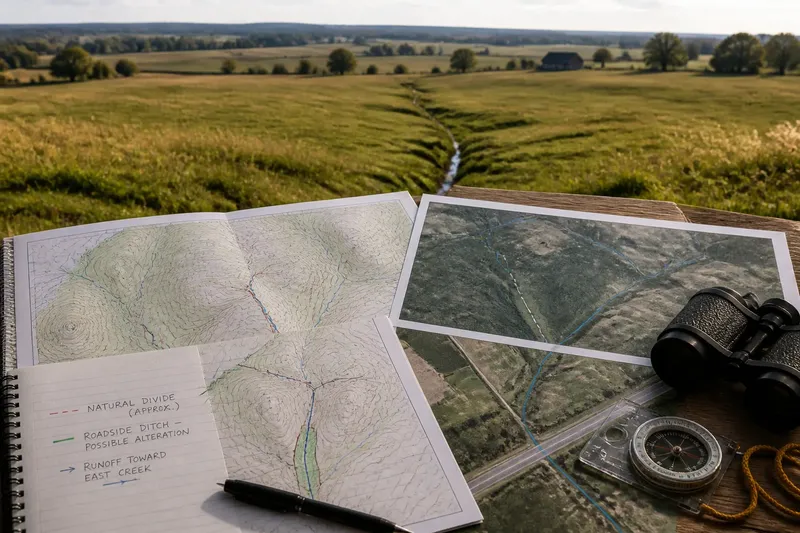
You can stand on a broad, grassy field and be close to a watershed divide without seeing a ridge or even a convincing slope. A watershed boundary is the high ground separating areas that drain to different outlets, but the high ground may be so subtle that a map, a ditch or a paved curb reveals more than the view.
Which approach fits depends on what you need to know. A rough answer for a walk, a defensible boundary for a school map and a drainage decision for a building site call for different evidence. The useful question is not simply “Where is the divide?” but “How precise must this boundary be, and what could change the route water takes?”
Do you need a quick sense of which way the land drains?
If you are orienting yourself outdoors, start with a topographic map rather than trying to spot a dramatic crest. Contour lines mark elevations; where they form a rounded high area, water generally drains away on opposing sides. The divide follows the higher ground between those directions, not necessarily a sharp line on the landscape.
Then compare the map with visible features: the shoulder of a hill, a shallow swale, a road crown or a field that gently falls toward a low spot. These clues help you form a working picture, not certify an exact boundary. A low, nearly flat stretch may send water in different directions depending on tiny changes in grade.
For a casual outing, a trail map with contour lines and a broad-scale watershed layer may be enough to identify the likely drainage side. Treat the line as approximate if the map’s terrain detail is coarse or the ground has been reshaped. A flat-looking boundary is not evidence that no divide exists; it may simply be hard to see at that scale.
Are you tracing a watershed on a map?
Use a topographic map or a digital elevation model that displays the terrain, then follow the high ground between neighboring drainage areas. A divide typically runs along ridges and local rises, linking higher points while staying out of channels and depressions. Check the direction of nearby streams: tributaries on opposite sides should lead toward different outlets.
Look for more than one source of evidence. A mapped watershed layer can give you a useful starting line, while contours and stream networks let you judge whether the line makes sense on the ground. If the boundary crosses gentle terrain, inspect the elevation surface at a closer scale and compare it with aerial imagery; a road embankment or drainage ditch may be visible in one view but obscure the natural shape in another.
Imagine you are sketching a divide across a gently rolling farm field between two creek systems. The contour pattern suggests a low rise, but a roadside ditch appears to carry runoff toward one creek. Mark the natural divide as approximate, note the ditch as a possible alteration, and avoid presenting the sketched line as a surveyed boundary.
Scale matters because small terrain features can disappear when many acres are compressed into a small map. A line drawn from a regional map may be suitable for explaining which basin contains a town, yet too rough for deciding which side of a fence drains into a particular swale. The detail should match the decision, not the temptation to zoom until the map looks precise.
Has construction or drainage work changed the route?
If the area includes roads, culverts, storm drains, levees, canals or filled ground, the natural divide may not describe present-day runoff. A road can intercept water and send it through a culvert; a storm sewer can carry it across a subtle crest toward another outlet. In built areas, the effective drainage boundary may follow infrastructure rather than the underlying high ground.
For a neighborhood question, check municipal stormwater maps, drainage plans or local watershed data if available. These records can show managed flow paths that a terrain map cannot. If the question concerns a specific property or proposed work, local drainage documents and a qualified surveyor or drainage professional are more appropriate than an online watershed line.
Do not assume every curb, ditch or pipe redirects an entire watershed. Many features affect only a small patch, and their influence can depend on how they connect to the wider drainage network. What is not worth the effort: tracing every lawn slope by eye when the question is simply which major river basin a community belongs to.
Which source should you use for your situation?
- For general orientation: Use a regional watershed map and a topographic map together. The first names the basin; the second helps explain the high ground that separates it.
- For a classroom or field sketch: Use contour lines, visible landforms and stream directions, and label uncertain stretches as approximate.
- For a town or planning discussion: Compare the mapped watershed with local drainage or stormwater records, especially where roads and pipes cross low rises.
- For a property-level decision: Seek site-specific mapping or professional advice rather than relying on a generalized basin layer.
Map labels, data methods and local drainage conventions can differ; where a boundary affects a formal decision, follow the relevant agency’s records and consult a qualified professional.
What questions help settle a difficult boundary?
Can a watershed divide run across flat land?
Yes. A small change in elevation can send water toward separate drainage systems even when the surface appears level. The boundary may be easier to identify from detailed terrain data than from a standing viewpoint.
Does a property line follow a watershed divide?
Not necessarily. Property lines are legal boundaries, while a watershed divide is a drainage boundary; the two may cross at any angle or lie far apart.
Can a storm drain carry water across the divide?
It can redirect runoff through a pipe or channel, so the present drainage pattern may differ from the natural terrain. Check local stormwater information when infrastructure is part of the question.
Why do watershed maps show different lines?
Maps can use different terrain detail, data sources or definitions of drainage, and some may account for engineered flow while others emphasize natural landforms. Compare the map’s purpose and scale before treating one line as more precise.
What should you conclude when the line stays uncertain?
State what the evidence supports: perhaps the broad basin is clear, while the divide’s exact route across a flat or altered patch is not. A careful map can show a likely boundary and mark the section that needs finer terrain data or local records. That is more useful than drawing a crisp line that implies certainty the landscape does not provide.
The watershed divide is a boundary of drainage, not always a ridge you can point to. For a broad question, a watershed layer may be enough; for a subtle or engineered site, combine terrain clues with local drainage information. When you search for a watershed boundary, match the source’s scale and purpose to the decision, and let uncertainty remain visible where the land keeps it hidden.